Description
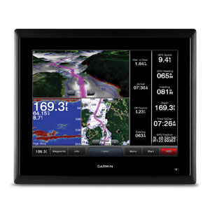
16-inch Multi-touch Widescreen Chartplotter/Sonar Combo
- 16-inch multi-touch widescreen display (1366×768 WXGA) with worldwide basemap
- Built-in dual CHIRP sonar plus CHIRP ClearVü and CHIRP SideVü scanning sonar with the clearest images on the water (transducer sold separately)
- High-sensitivity internal 10 Hz GPS/GLONASS
- Fully network capable for Garmin Marine Network and NMEA 2000®, plus NMEA 0183 support
- Supports premium GSD™ sonar module
Designed for sportsfishermen, cruisers, sailors and sailing racers who demand high performance, ease of operation, and feature integration in a chartplotter/sonar combo. The 16-inch multi-touch widescreen GPSMAP 7416xsv includes built-in dual CHIRP sonar plus CHIRP ClearVü and CHIRP SideVü scanning sonar with the clearest images on the water. Also supports 50 kHz/200 kHz, 77 kHz/200 kHz plus Minn Kota® and MotorGuide® trolling motor transducers. Internal 10 Hz GPS updates your position and heading 10 times per second.
Fully network capable, including Garmin Network and NMEA 2000 (radar, autopilot, instruments, multiple screens, FUSION-Link, sensors, black box sonar, digital switching, thermal cameras, GRID and more), GPSMAP 7416xsv also offers the conveniences of built-in Wi-Fi® connectivity.
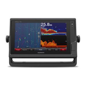
Built-in Advanced Sonar Capabilities
The built-in sonar capabilities of the GPSMAP 7416xsv include 1 kW dual CHIRP sonar, the most sophisticated sonar technology available for the fishing and boating public. It also includes both CHIRP ClearVü and CHIRP SideVü scanning sonar that provide nearly photographic sonar images of fish and structure that passes below and to the sides of your boat. ClearVü and SideVü provide the clearest scanning sonar images on the water. Also supported are 50 kHz/200 kHz, 77 kHz/200 kHz and Minn Kota and MotorGuide trolling motor transducers (transducers sold separately).
Garmin Marine Network and NMEA 2000 Support
Full-network compatibility allows you to add more to your boat. GPSMAP 7416xsv supports radar, autopilot, instruments, multiple screens, FUSION-Link, sensors, remote sonar modules, digital switching, thermal cameras, GRID™ and more.
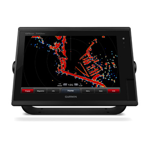
Add Array or Dome Radar
You can add your choice of Garmin marine radar, including our powerful xHD2 open array radars or xHD dome radars that pair ease of use with advanced open array features.
Network Sharing
GPSMAP 7416xsv allows you to share features with other compatible GPSMAP units, such as radar, supplemental maps and user data, including waypoints, routes and tracks. User data entered into 1 chartplotter can be automatically synced with other chartplotters in a network.
Heading, Position Refreshed 10 Times per Second
Fast, responsive 10 Hz GPS/GLONASS refreshes your position and heading 10 times each second to make your movement on the screen more fluid. It makes dropping up to 5,000 accurate waypoints and finding your way back them quick and easy.
Special Sailing Features
Supported sailing features include laylines, enhanced wind rose, heading and course-over-ground lines, true wind data fields and tide/current/time slider. Racing features include pre-race guidance, synchronized race timer, virtual starting line, time to burn and lay line data fields. Gauge displays are designed to provide important need-to-know information at a glance, including true and apparent wind angle, set and drift, true or apparent wind speed, horizontal or vertical graphs, and a data bar with customizable data fields.
Upgrade with our Best Maps on the Water
Two SD™ card slots provide expandable memory for accessory map purchases such as, LakeVü HD, LakeVü HD Ultra or BlueChart® g2 or BlueChart g2 Vision®.
GND™ 10 Black Box Interface
The GND 10 black box interface seamlessly integrates Nexus instruments and sensors with the Garmin family. It converts data between the Nexus network and NMEA 2000 to provide trouble-free compatibility between Nexus and Garmin products, including gWind™ and gWind Race transducers.
Compatible with gWind Transducers
gWind, gWind Wireless and gWind Race transducers feature twin-fin technology with 3-bladed propeller. Connect to the NMEA 2000 and compatible Garmin chartplotters via the GND 10 black box bridge.
FUSION-Link Entertainment System
Enjoy the ability to control all compatible FUSION-Link-enabled audio systems directly from your compatible chartplotter display.
The Ultimate Connected Boating App
Built in Wi-Fi gives you access to the free all-in-one ActiveCaptain® app, so you can manage your marine experience from nearly anywhere. It creates a simple yet powerful connection between your compatible mobile device and your Garmin chartplotter, charts, maps and the boating community. Wherever you are, you’ll have unlimited access to your cartography, the ability to purchase new maps and charts and access to the Garmin Quickdraw™ Contours Community. Stay connected with smart notifications on your chartplotter screen. You can also plan a trip or prefish a lake, and ActiveCaptain will automatically sync with your chartplotter. Even get notifications for software updates, and decide when to download them on your device.
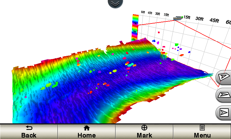
Panoptix™ Down Transducer
With 1 Panoptix Down transducer, you get 3 remarkable views, allowing you to actually see fish and bait swimming around under your boat – in real time. You can even see fish in the water column in 3-D, from the bottom to the surface. You can be stationary yet still see things in 3-D below your boat.
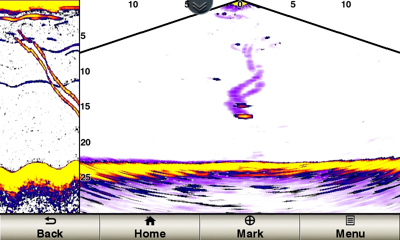
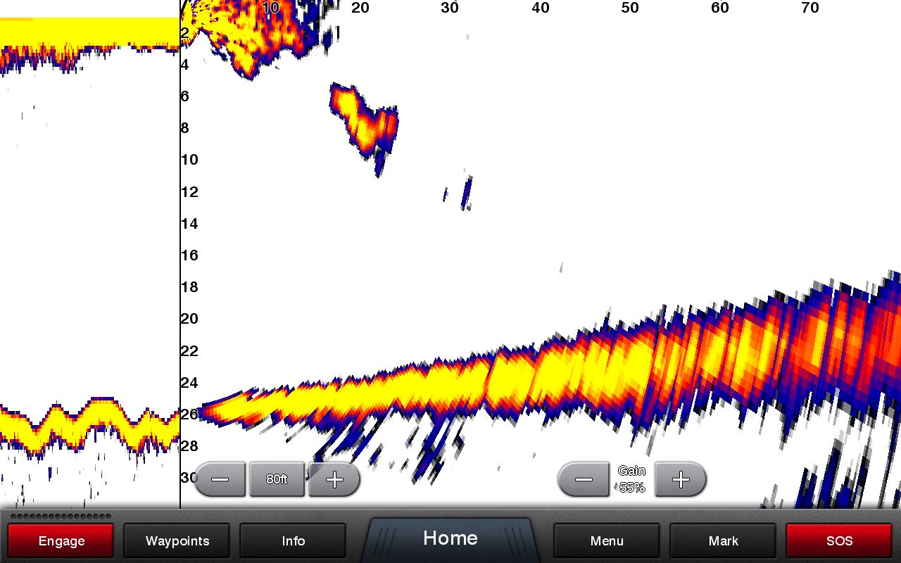
LIVEVÜ DOWN
Shows real-time moving sonar images below the boat. This screen shows bait drop echo trail movement in purple with sonar history data at left.
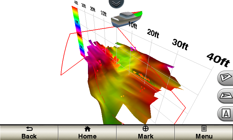
REALVÜ 3-D DOWN
Scans the area below the boat from front to back and side to side. This screen shows a school of fish sitting against the back side of vertical face, on Pport side of boat 35 feet deep.
REALVÜ 3-D HISTORICAL
Scrolls through the data as the boat moves to show the history of entire water columns – from the bottom to the surface and all of the fish in between. This screen shows the boat passing over a stream channel with a school of fish between 30 to 40 feet.
Panoptix Forward Transducer
One Panoptix Forward transducer provides 2 impressive views, even while your boat is stationary. It shows the bottom plus fish and bait swimming in the water column in front of your boat – in real time. You can even see your lure as you reel it in. You can also get 3-D views of fish and structure in front of your boat.
LIVEVÜ FORWARD
Updates are provided with a single ping, providing real-time moving images of what’s in the water. This screen shows a large target (a diver) approaching the boat.
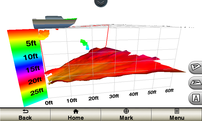
REALVÜ 3-D FORWARD
Digitally scans the area in front of the boat, creating a forward-looking 3-D view of the bottom, structure and fish. This screen shows fish targets at 10 feet and drawing bottom depth of 20 feet.
Create your own HD maps
Quickdraw Contours is a free, easy-to-use software feature already installed on your compatible Garmin combo. It instantly creates your own personalized HD fishing maps with 1-foot contours. Tailor them to fit your needs. They are your maps — you own them. Keep the data to yourself, or share it with the Quickdraw Community on Garmin Connect™. There’s no special surveying expertise required. You just fish while it creates maps. You don’t have to wait around or send your files away like other mapping software requires — your results appear instantly. Use with any of the following sonar transducers: Garmin Panoptix™, HD-ID™ traditional, CHIRP-enabled, Garmin ClearVü™ or NMEA 2000®-compatible depth. Have more than 1 sonar device installed onboard? Quickdraw Contours automatically selects the most capable sonar device to provide the very best results for you!
Multiple Depth Range Shading
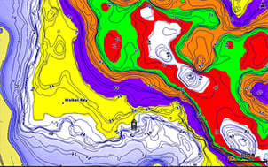
Designate up to 10 different depth ranges each with its own color. Makes it easier to view target depths at a glance.
Commission Autopilot from Chartplotter
To make commissioning easier and more convenient, you can handle the entire autopilot commissioning process from your chartplotter screen.
Axis and FLIR Camera Support
Garmin offers support for select Axis cameras and for select FLIR cameras. These can be used for surveillance and situational awareness on vessels of any size. You can control your camera’s pinch-to-zoom and pan/tilt settings with gestures directly on the plotter screen and view video on multiple screens as well as multiple video streams on the same screen. Use an Axis encoder to convert analog camera, such as Garmin GC 10, to video over IP.
Catch All the Action On the Water
This chartplotter supports wireless connections to Garmin VIRB® X and XE action cameras so you can catch all the action during your time on the water. More importantly, with a simple software update, you can control recordings, take still pictures, and stream video from a VIRB X/XE action camera to your GPSMAP® 7400/7600 series chartplotter or 8000/8400/8600 series Glass Helm chartplotter. In fact, you can stream video from up to 4 VIRB X/XE action cameras and view the video on a compatible marine chartplotter. You can even view previously captured images and videos on the chartplotter and display thumbnail previews for easy selection. Control play, pause, seek and replay from your chartplotter. There’s even an automatic slide show mode and the ability to delete unwanted VIRB images or videos. Each VIRB can be named for easy identification. You can also control your VIRB cameras to change VIRB video settings, including aspect ratio, video resolution, frames per second, photo size, field of view and more — directly from the marine chartplotter. Send NMEA 2000 boat information from the chartplotter to VIRB X/XE to be overlaid as G-Metrix™ data on the video using VIRB Edit or the VIRB mobile app. Some data requires optional accessories.
General |
|
| Physical dimensions | 16.8″ x 10.8″ x 3.4″ (42.7 x 27.4 x 8.6 cm) |
|---|---|
| Display size | 13.6″ x 7.6″; 15.6″ diagonal
(34.5 x 19.3 cm; 39.6 cm diagonal) |
| Display resolution | 1366 x 768 pixels |
| Display type | WXGA display |
| Weight | 9.5 lbs. |
| Water rating | IPX7 |
| Power consumption |
|
| Antenna | Internal or external over NMEA 2000 |
| Mounting options | Flat and flush, bail with optional accessory (Garmin does not offer any hardware or accessories for a flat-mount installation. Professional tools and knowledge is required.) |
| Receiver | 10 Hz GPS/GLONASS |
| Garmin Marine Network™ ports | 2 |
Maps & Memory |
|
| Preloaded maps | None |
|---|---|
| Accepts data cards | 2 SD™ cards |
| Waypoints | 5,000 |
| Routes | 100 |
| Track log | 50,000 points; 50 saved tracks |
Outdoor Recreation Features |
|
| Tide tables | |
|---|---|
Chartplotter Features |
|
| Garmin Radar compatible | |
|---|---|
| Garmin Sonar compatible | Yes |
| Garmin SmartMode compatible (customizable monitor presets) | |
| Supports AIS (tracks target ships position) | |
| Supports DSC (displays position data from DSC-capable VHF radio) | |
| Garmin Meteor™ Audio System compatible | |
| Supports FUSION-Link™ compatible radios | |
| GSD™ Black Box sonar support | |
| GCV™ Black Box sonar support | |
| ActiveCaptain compatible | |
| Garmin Helm compatible | |
| GRID™ (Garmin Remote Input Device) compatible | |
| Wireless remote compatible | |
Sonar Features & Specifications |
|
| Dual-frequency (50/200 kHz) sonar capable | |
|---|---|
| Dual-beam (77/200 kHz) sonar capable | |
| Transmit power | 1 kW traditional; 1 kW CHIRP |
| CHIRP sonar technology | Yes (Built-in) |
| ClearVü | Yes with CHIRP (built-in) |
| SideVü | Yes with CHIRP (built-in) |
| Maximum depth | 5,000 ft at 1kW (depth capacity is dependent on water bottom type and other water conditions) |
| Bottom lock (shows return from the bottom up) | |
| Water temperature log and graph | |
| Sonar recording | |
| Sonar history rewind | |
Connections |
|
| NMEA 2000® compatible | |
|---|---|
| NMEA 0183 input ports | 2 |
| NMEA 0183 output ports | 2 |
| Video input ports | 2 Composite |
| Video output ports | 1 DVI-D |
| Wireless connectivity | |
Additional |
|
| Additional |
|
|---|---|